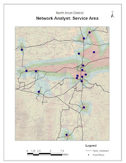
Aim:
To create a Service Map through the use of
Network Analyst toolset
Procedure:
Step 1: Map Input
A Base map or toposheet on which Roads and Facilities Point
features are digitized and exported as shapefiles.
Step 2: Map
Processing
·
Geo-reference the base map with known location
coordinates.
·
Import the digitized Line and Point shapefiles
into the target Geo-database.
·
All Line entities of road feature class, needs
to be split into right-angles at junctions. Hence use the Planarize line tool
from Topology tool options under Editing mode.
·
In ArcCatalog, create a Network Dataset and add
Road features.
·
Enable the Network Analyst option in Extension
and choose the Service Area analysis.
 ·
For Service Area analysis, the location of
Facilities point is mandatory. One may choose to identify these Facility
Locations manually or load point location shape file created from the base map.
·
On properties of Service Area, Set the Impedance
to Break Values of Length in Meters.
·
Solve for Service Area. The Service Area (In
custom Break Values) will be generated for Facilities Point Location.
Step 3: Map Display
The final Output map
can be displayed with Map Elements and grid properties of Layout.
Conclusion:
A Service Area Map through the use of Network Analyst
toolset is created.
No comments:
Post a Comment