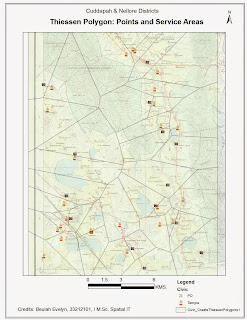
Aim:
To create a Thiessen Polygons for the given Map using the
chosen Point attributes.
Procedure:
 Concept: Entities
have area of Influence, which we can tag as “Service Areas” or “Sphere of
Influence”. For Example, Post Offices that cater to particular zone, Places of
religious worship that is accessible to the residents of a particular
zone,… Now, though these are completely
two different entities, there could be instances where a particular feature
types is repeated at a closer proximity within a zone. Example, a section in the zone which has two
temples. Now which temple would be more proximate to which part of the zonal
section? Another more obvious example
will be habitats which have their own spatial areas of habitation, there is no
physical or political boundary here, but just the sphere of influence, based on
the distance between two or more entity features. The non-uniform spread of features uses its
own distance weighing attributes to compute Influential Zones of Polygons.
Step 1: Map Input
Identify the Point entities component for the location
dataset. For this session, Post Offices and Temples (Hindu Place of Worship)
were digitized from the given topographic map of Nellore & Cuddapah
Districts. The Point Entities were saved
as “Civic Areas”.
Step 2: Map
Processing
- · Digitize the Point Entities for Selected entities. Perform Attribute Editing. “Add Field” for “Name” and “Weights”. Specify the Name (Temples or PO) in the Attribute Window.
- · Locate the “Create Thiessen Polygons” tool in Analysis -> Proximity, toolbox.
- · Define the Tool Input “Civic Areas” and specify the target output folder.
- · Click “Ok” to generate the map output
Step 3: Map Display
Create Custom Map Layout with the necessary map elements and
Export map to Jpeg format
Conclusion:
Thiessian Polygon maps for the chosen polygon attributes are generated using ArcGis 10.1.
No comments:
Post a Comment